
Our vision is to equip water decision-makers in the western U.S. with useful, accessible and sustained remote-sensing-based information. WWAO works to build water projects that deliver real impact. We do this with the help of three teams:
Better snowpack information is a common need within the Colorado, Columbia and Missouri River Basins. Water managers need improved snow data for:
NASA’s work in snow science has created several relevant capabilities that can help water managers:
The Airborne Snow Observatory (ASO) is a NASA aircraft mission designed to quantify how much snow lies on a landscape and how quickly it is likely to melt away. The data could help improve water management for 1.5 billion people worldwide who rely on snow melt flowing out of major water basins for their water supply.
The ASO is a collaboration between NASA's Jet Propulsion Laboratory and the California Department of Water Resources. The mission began a three-year demonstration in April 2013, flying onboard a Twin Otter aircraft that makes weekly flights over the Tuolumne River Basin in California and monthly flights over the Uncompahgre River Basin in Colorado during the snow-melt season. These basins are the primary water supply for millions of Americans in the western United States.
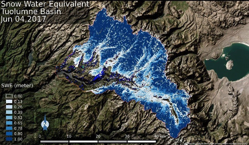
ASO incorporates an imaging spectrometer that measures snow cover, albedo and grain size, and a LIDAR (laser altimeter) that calculates snow depth. The mission created the first maps of the entire snow pack of two major mountain watersheds in California and Colorado, producing the most accurate measurements of how much water they hold. ASO also made the first measurements of snowfall precipitation over entire mountain basins, providing atmospheric scientists and hydrologists with their first spatially complete understanding of precipitation in mountains.
ASO provides water managers with basin-wide snow water equivalent, snow depth, and snow albedo. The objective of this WWAO project is to incorporate ASO data into precipitation runoff models in order to improve forecasts of runoff through the Sierra Nevada mountain range, which is located primarily in California. Decision makers will potentially use the information to inform decisions about water allocation and reservoir operation, including hydroelectric generation and flood management.
Geographic focus:
California, Colorado
End users / decision makers who could benefit:
California Department of Water Resources, U.S. Department of Agriculture Agricultural Research Service, San Francisco Public Utilities Commission, irrigation districts.
Data sources, models, and technology being harnessed:
ASO (with imaging spectrometer and LIDAR instruments); ASO-derived measurements of snow depth, snow water equivalent and albedo.
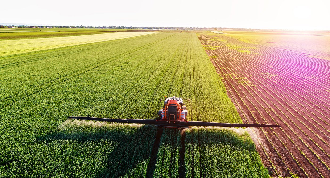
Food grows where water flows, and food and water security are inextricably linked. The goal of this project is to use satellite images to track crop activity and map the impact of drought on fallowed (uncultivated) land in the western United States. It is a collaborative effort between NASA Ames Research Center, the California Department of Water Resources, the U.S. Geological Survey, the U.S. Department of Agriculture, and California State University, Monterey Bay.
California is the top food-producing state in the nation with an output per acre unmatched by other states. Its roughly 80,000 farms produce over 400 commodities, including two-thirds of the United States’ fruits and nuts. About a quarter of the food California produces is exported around the world.
Satellite images can be used to monitor the extent of idle and cropped acreage on a monthly basis. Following the successful demonstration of this technique in the Central Valley of California, and in direct response to state agency requests to extend the capability beyond California, NASA WWAO supported the extension of this Fallowed Area Mapping project to the states of Washington and Nevada. Results show that it is possible to track the impact of drought on agricultural-land fallowing in near-real-time, and offers great potential in helping inform drought plans and responses, particularly as part of the National Integrated Drought Information System Drought Early Warning System.
Geographic focus:
Washington and Nevada
End users / decision makers who could benefit:
Washington Department of Ecology, Washington Department of Agriculture, Nevada State Engineer’s Office.
Data sources, models, and technology being harnessed:
Landsat, MODIS, Sentinel-2A, NAIP, NEX.
Project lead:
Dr. Forrest Melton, NASA Ames Research Center Cooperative Agreement for Research in Earth Science and Technology
The focus of this WWAO project is on building a Land Information System (LIS) that offers NASA’s best assessment of water availability to decision makers in the western United States. It leverages NASA’s existing land-surface modeling and satellite-data assimilation tools in a configuration that is optimized for the western states. The LIS infuses data on soil moisture, snow-water equivalent, evapotranspiration, runoff, groundwater levels and streamflow.
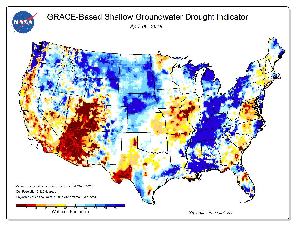
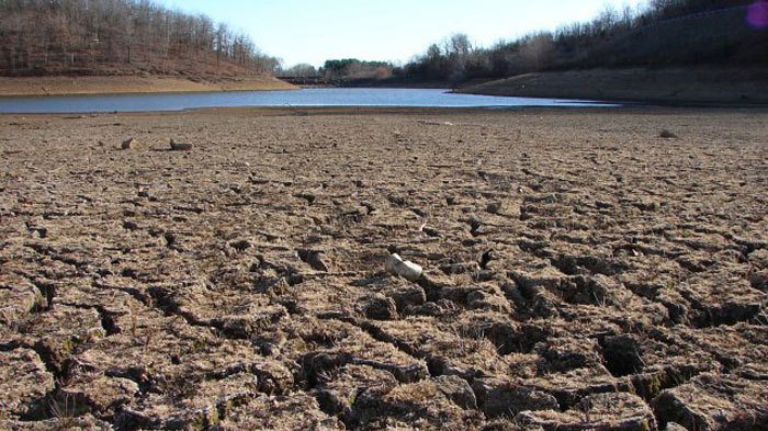
One goal of the work is to provide a clearer picture of how drought affects water quality. Another potential use is to offer better estimates of groundwater depletion, a key issue facing not just the western United States but many regions of the world. In the longer-term, the LIS could potentially provide inputs to California’s recent Sustainable Groundwater Management Act of 2014, and the 200-300 Groundwater Sustainability Agencies that must ensure compliance.
Geographic focus:
Initial focus on California with potential expansion to stakeholders in the greater western United States.
End users / decision makers who could benefit:
California State Water Resources Control Board, California Department of Water Resources, California Department of Food and Agriculture, California Groundwater Sustainability Agencies.
Data sources, models, and technology being harnessed:
SMAP, GRACE, MODIS/VIIRS, ASO, land-surface models.
Project leads:
Dr. Christa Peters-Lidard and Dr. Matthew Rodell, NASA Goddard Space Flight Center; Dr. Jay Famiglietti, University of Saskatchewan.
New Mexico is among the most arid states in the United States and consistently suffers from drought conditions that make agriculture, ranching, grazing, fire response, and other water-related activities difficult to manage. This project is working to deliver to the New Mexico Office of the State Engineer remote-sensing-based information that it can use to assess agricultural water use and drought conditions across the state, and improve water planning, particularly during droughts.
Geographic focus:
Initial focus on California with potential expansion to stakeholders in the greater western United States.
End users / decision makers who could benefit:
New Mexico Office of the State Engineer, U.S. Bureau of Reclamation, New Mexico State Forestry, New Mexico Department of Agriculture, New Mexico Fish and Game, U.S. Geological Survey.
Data sources, models, and technology being harnessed:
Evapotranspiration, potential evapotranspiration, evaporative stress index, normalized difference vegetation index, albedo, land surface temperature, MODIS.
Project lead:
Dr. Joshua Fisher, NASA Jet Propulsion Laboratory
This work is focused on helping growers and water managers in the western United States make more informed and efficient decisions about the amount of water and fertilizer to apply to crops. By combining two existing online tools (NASA’s Satellite Irrigation Management system (SIMS) and CropManage), satellite, weather and soil data can be used to help growers tailor irrigation times and nutrient application to the specific needs of crops like lettuce, strawberries, broccoli and cabbage. NASA’s Satellite Irrigation Management system provides detailed maps and trends of crop canopy conditions and irrigation demand, while CropManage is an app that helps growers and water managers make water and nitrogen-fertilizer decisions at the field level.
Initial results suggest that water use can be significantly reduced with no loss of yield or quality for a variety of crops. The combined SIMS-CropManage system is also expected to lower the cost of planning, water budgeting and reporting for compliance with California’s Sustainable Groundwater Management Act.
Geographic focus:
Initial focus on California with potential expansion to stakeholders in the greater western United States.
End users / decision makers who could benefit:
Commercial growers / shippers, agricultural water managers including farmers primarily on the California Central Coast (at least to start with), crop consultants, irrigation districts, groundwater sustainability agencies, state agencies.
Data sources, models, and technology being harnessed:
Landsat, MODIS, Sentinel-2, Satellite Irrigation Management system, CropManage app, remote-sensing-based vegetation indices, green fractional-crop cover, basal crop coefficients.
Project lead:
Alberto Guzman, Ames Research Center Cooperative Agreement for Research in Earth Science and Technology
The Navajo Nation is the largest federally-recognized Native American tribe in the United States in terms of land area, covering over 70,000 km2 and occupying parts of northeastern Arizona, southeastern Utah, southern Colorado, and northwestern New Mexico. With a population of over 200,000, the Navajo Nation is prone to frequent and pervasive droughts, and suffers from poor water-supply reliability. Over 40% of homes do not have direct access to potable water and must rely on water haulers.
The goal of this project is to help improve the Navajo Nation Department of Water Resources Drought Report, which is presented to emergency managers and used to allocate drought-relief funding throughout the community. Drought-relief funds, which of the order of $25 million, are currently disseminated throughout the Navajo Nation evenly among all agencies. A more informed Drought Report would enable funds to be allocated in proportion to drought severity and needs.
End users / decision makers who could benefit:
Navajo Nation Department of Water Resources, Navajo Nation Department of Emergency Management.
Data sources, models, and technology being harnessed:
Navajo Nation rain-gauge data, multi-satellite precipitation product from TRMM and GPM, integrated multi-satellite retrievals for GPM, Climate Hazards Group InfraRed Precipitation with Station data (CHIRPS) (a quasi-global rainfall dataset), Drought Severity Evaluation Tool.
Project lead:
Dr. Amber McCullum, NASA Ames Research Center
Operational agencies like the U.S. Department of Agriculture’s National Agriculture Statistics Service (NASS) provide agricultural forecasts and assessments that rely on best estimates of soil moisture. Currently these are created using ground input from farmers or field offices, which is an expensive approach that offers only sparse observations across different counties. For better forecasts, they need estimates that track changes in soil moisture with fine resolution over both space and time.
This WWAO-funded project is working to explore the feasibility of using soil-moisture data from satellites to improve measures of soil moisture at both ground-level and in the root-zone for NASS, and to satisfy its operational data needs. The information will be helpful for the NASS Crop Weather report, crop grower associations and other agricultural groups.
End users / decision makers who could benefit:
U.S. Department of Agriculture’s National Agriculture Statistics Service (NASS) (Pacific and Northern Plains Regions), crop grower associations such as the Almond Board, agricultural extension groups and university contacts.
Data sources, models, and technology being harnessed:
SMAP, SMOS, SMAP-Sentinel product.
Project lead:
Dr. Rajat Bindlish, NASA Goddard Space Flight Center