
NASA to Showcase Earth Science Data at COP28
NASA will share its Earth science data and knowhow at the 28th U.N. Climate Change Conference of the Parties (COP28).
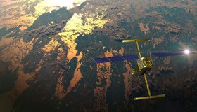
US-French Satellite Takes Stock of World’s River Water
In a first, a space mission led by NASA and France has tracked Earth’s rivers swelling and shrinking from month to month over the course of a year and found significantly less of a swing than previous model-based estimates.
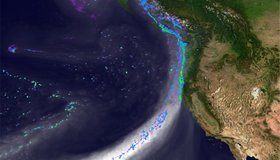
Wet Soils Increase Flooding During Atmospheric River Storms
A new study published in the Journal of Hydrometeorology this month demonstrates that the amount of water in soil, in addition the strength of a storm, can determine the risk of flooding.

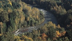
Informing Food Security and Health Applications in the Chesapeake Watershed with Remote Sensing
The Chesapeake Bay Working Group at Goddard includes several stakeholders who collectively review how NASA satellite data can help support a variety of needs in the largest North American estuary.
Leveraging Earth Observation Data for Practical Water Management in the Western US
Today, the unique water resource management challenges of the western US, amplified by population growth, changing weather patterns, and a rapidly expanding water- and energy-hungry tech sector, continue to drive innovative West-focused solutions, like NASA’s WesternWater Applications Office (WWAO).

Improving Drought Predictions by Tackling Challenges in Simulating Snow
In a collaborative effort for better snow prediction, scientists are upgrading a well-known climate model to simulate sunlight reflection on snow.
Freshwater Trust Awarded $1 Million Grant to Reduce Flood Risk
The research-based grant has been designed to quantify the benefits of floodplain restoration projects as a means to deliver multiple community and environmental benefits.
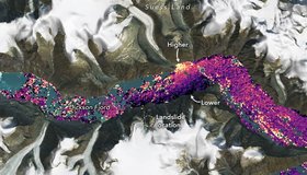
International SWOT Satellite Spots Planet-Rumbling Greenland Tsunami
Data from space shows water tilting up toward the north side of the Dickson Fjord as it sloshed from south to north and back every 90 seconds for nine days after a 2023 rockslide.
Mapping Groundwater-Dependent Ecosystems
Many diverse ecosystems rely on groundwater for a stable water supply. Species can rely directly or indirectly on groundwater for some or all their water requirements, depending on a multitude of factors.
GPM Mission Celebrates Ten Years of Observing Precipitation
On February 27, 2014, the four-ton Global Precipitation Measurement (GPM) Core Observatory spacecraft launched aboard a Japanese H-IIA rocket from Tanegashima Space Center in southern Japan.