Tracking Water For The Navajo
A new web tool designed by WWAO scientists could help the Navajo Nation anticipate and respond to drought. The latest maps give insight into the moderate to severe drought conditions affecting much of the area.
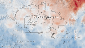
Seeking Relief From Drought, Navajo Turn to NASA
On the Navajo Nation, access to drinking water is limited. Over 40 percent of homes lack running water. The community is hit by frequent, pervasive drought. WWAO is developing a new drought tool that, with the help of satellite data, will enable Navajo water managers to hone in on drought severity and better manage the water they have.
Changes Loom for Innovative Lower Colorado River Endangered Species Program Amid Drought, New River Rules
The Colorado River flow, once a reliable source for endemic wildlife, has been reduced since the construction of the Hoover Dam and dispersal to growing human populations in the states of the Southwest, endangering the life of some wildlife species.
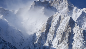
Improving Drought Predictions by Tackling Challenges in Simulating Snow
In a collaborative effort for better snow prediction, scientists are upgrading a well-known climate model to simulate sunlight reflection on snow.
Better Ways to Promote Urban Water Conservation
Reducing water use in cities and suburbs is key for helping communities get through droughts. The Public Policy Institute of California discusses how to optimize urban water conservation.
Whiplash weather: Learning From California’s Deadly Storms
How can communities better prepare for the dramatic swings between flood and drought that the western U.S. is experiencing?

Reaching New Levels in Groundwater Monitoring
As regions around the world face record-breaking droughts, scientists are using seismology to track groundwater levels, showing that well-managed pumping strategies have a big impact.
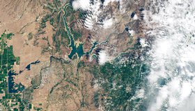
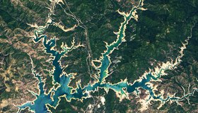
NASA Images Hone in on California’s Severe Drought
California’s reservoirs are rapidly drying up and the water level in Shasta Lake — the largest reservoir in the state — has dipped to about 35% of its capacity. The L.A. Times spoke to WWAO about how the drought looks from space.
NASA Strengthens Our Resilience to Drought
In the face of severe west-U.S. drought, NASA has launched a new page highlighting its eyes on the drought, which are helping track and monitor the ongoing drought, predict how much water will be available, and improve how we use the water we have.
California Reservoirs Reflect Deepening Drought
Four years after California emerged from a severe multi-year drought, the state’s precipitation and lake levels are among their worst since the 1970s. The deepening drought is seen in satellite images of the state’s two largest reservoirs.