
Seeing COVID From Space
NASA is tracking the effects of the COVID-19 pandemic on our air, land, water and climate. The data have been collected in a free, openly-available online dashboard.
NASA, USDA Increasing Innovation in Agriculture
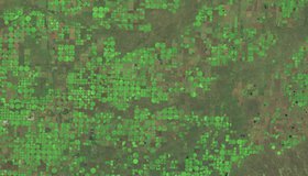
A new agreement between the U.S. Department of Agriculture and NASA will strengthen agricultural and Earth science research. WWAO’s collaboration with the USDA on its High-Resolution Soil Moisture Project fits into this larger partnership.

Sea-Level Projections Drive San Francisco's Plans
Access to the latest information about sea-level rise is crucial to many coastal cities. New NASA research is helping San Francisco plan measures to adapt to rising seas.

WWAO Passes The Baton to The Navajo
We have liftoff! NASA WWAO's new Drought Severity Tool is operational and has been handed off to its tribal partner, the Navajo Nation, as the project comes to a close.
New Ocean Satellite Releases Impressive First Data
Launched three weeks ago, the Sentinel-6 Michael Freilich satellite has returned its first data and is surpassing expectations. The NASA-U.S.-European satellite will measure sea-level rise with unprecedented accuracy.

NASA-Navajo Drought Tool User Guide Launched
WWAO's Navajo Nation Drought Tool User Guide is now live. This marks a milestone in the transition of our Navajo Drought Project from research to decision makers, and is key to building capacity within the Navajo community to use the tool.
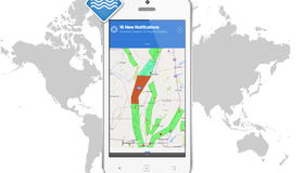
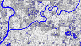
Early Access to Global Flood Tracking
Floods are the most deadly and costly natural hazard. A NASA team is streamlining access to real-time satellite data so disaster managers can make informed decisions, faster.
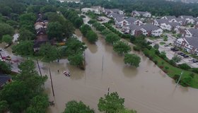
Satellites Improving Flood And Landslide Monitoring
NASA scientists Dalia Kirschbaum and Maggi Glascoe are using satellite data to pioneer improved landslide and flood alerting around the world.
NASA's Water Portal Launched
Our new NASA Water Portal is now live. The portal serves as a hub for building connections between our catalogs of Water Data Needs and Water Capabilities and our partners, including water managers, decision makers, and scientists.
Push to Make NASA Earth Data More Accessible
NASA has accumulated 40 petabytes of Earth science data, twice as much as all of the information stored by the Library of Congress. In the next five years, that will grow to 250 PB. 11 new projects are launching to help manage, store and search these data.