WWAO Passes Baton to U.S. Dept. of Agriculture
WWAO's new Soil Moisture Data System - Crop Condition and Soil Moisture Analytics (Crop-CASMA) - has been handed off to its agricultural partner, the U.S. Department of Agriculture (USDA)’s National Agricultural Statistics Service (NASS), as the project comes to a close.
The tool is the fruit of a collaboration between NASA, WWAO, the USDA and George Mason University. Its official launch represents a milestone in WWAO's effort to move its water work from research to operational status.
Crop-CASMA is unique in providing high-resolution, field-scale soil wetness from NASA satellites in an easy-to-use format. The tool offers more thorough spatial coverage and consistency than other soil-moisture measurement methods, harnessing data from NASA’s Soil Moisture Active Passive (SMAP) mission and the Moderate Resolution Imaging Spectroradiometer (MODIS) instrument. Crop-CASMA is helping USDA NASS move from using weekly surveys that provide qualitative soil moisture at county scale to quantitative estimates at high resolution (1 km) and at a 2-3 day temporal scale.
“Our current reports are at the state level. [But] one area of a state might be wet, while another dry. These new data deliver localized moisture readings – this is what matters to the farmer.”
Zhengwei Yang, U.S. Department of Agriculture National Agricultural Statistics Service
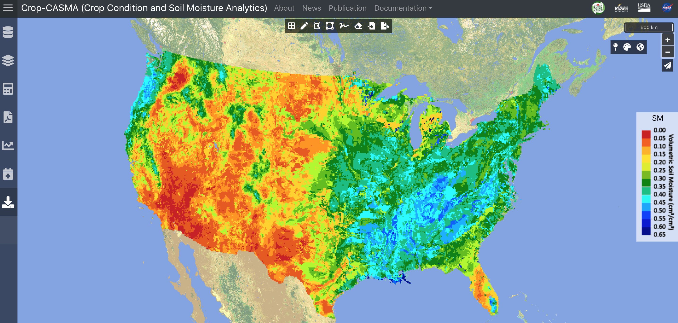
Example soil moisture map from the Crop-CASMA tool.
Water for food
Agriculture can be the largest consumer of water in the western U.S., and there is keen, growing interest from growers and water managers in using remotely-sensed data to improve how agricultural water is measured and managed. WWAO has a number of projects that work to respond to this need. These tools are helping farmers and water managers use NASA's Earth observations to better understand field conditions and conserve water use, while at the same time preserving crop yields.
WWAO's SIMS-CropManage Decision App helps farmers in California and other western states improve crop irrigation with satellite data. WWAO's Fallowed-Land Mapping Project has demonstrated the ability to map idle and cropped farmland in California, Washington and Nevada from space, bringing forward states' ability to assess the impact of drought on agricultural production by 6-9 months.
Crop-CASMA is the culmination of WWAO's High-Resolution Soil Moisture Project, led by Dr. Rajat Bindlish of NASA's Goddard Space Flight Center, and launched to develop high-resolution (1-km-scale) soil-moisture maps for the USDA.
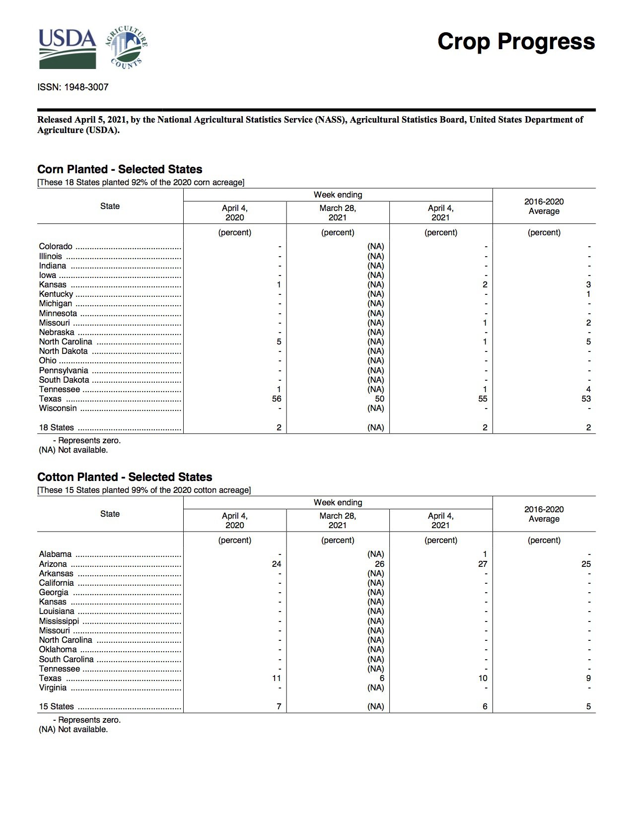
USDA NASS Crop Progress Report released on April 5, 2021.
As part of WWAO's focus on expanding the tool's use among other water partners, Crop-CASMA has been presented to the USDA Foreign Agricultural Service and the U.S. Forest Service, and will be presented to the Western States Water Council and the Western States Federal Agency Support Team (WestFAST) later this month.
Looking ahead, the high-resolution soil moisture data - specifically daily and weekly soil moisture composites with a target data latency of less than 24 hours - will continue to be gathered as part of NASA's food-security efforts. The information will be assimilated into NASA's Land Information System (LIS) in order to estimate root-zone soil moisture, and both surface- and root-zone soil moisture will be provided to USDA’s NASS.
Crop-CASMA is freely available to all online at https://cloud.csiss.gmu.edu/Crop-CASMA/.
Lead scientist: Dr. Rajat Bindlish, NASA Goddard Space Flight Research Center.
- Crop-CASMA - A High-Resolution NASA/USDA Soil Moisture Data Portal
- NASA/USDA press release on Crop-CASMA and WWAO's High-Resolution Soil Moisture Project
- NASA, USDA Increasing Innovation in Agriculture - NASA/USDA Agreement to Collaborate on Earth Science Research
- NASA's Land Information System - An Earth System modeling framework for high-performance terrestrial hydrology modeling and data assimilation. It integrates satellite- and ground-based data and modeling techniques to produce optimal fields of land-surface states and fluxes.