
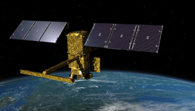
New SWOT Satellite to Survey World's Water
How much water sloshes around in Earth’s lakes, rivers, and oceans? And how does that amount change over time? The upcoming Surface Water and Ocean Topography (SWOT) mission plans to find out.

NASA 2021 Water Resources Solicitation
NASA has released a 2021 solicitation for water-resource proposals through NASA's Research Opportunities in Space and Earth Sciences (ROSES). The first-round deadline is May 21, 2021.

From Space to Farm
Farmers rely on the Landsat satellite to make decisions about crops, with far-reaching implications that can impact what we see on our dinner plate. In this curious video, Landsat's view of crops from space can be heard in the form of music.
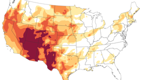
The Drying U.S. West
A serious drought has flared up across half of the United States, with about a third of the country suffering from extreme or exceptional drought. This familiar story has been playing out for the past two decades.

NASA-Navajo Drought Tool User Guide Launched
WWAO's Navajo Nation Drought Tool User Guide is now live. This marks a milestone in the transition of our Navajo Drought Project from research to decision makers, and is key to building capacity within the Navajo community to use the tool.

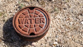
Disparities in U.S. Water Access
A new study reveals key disparities in piped water access in urban U.S. areas. From 2013 to 2017, 1.1M people had insecure water access, with half located in the 50 largest metropolitan areas. Gaps in water access are underpinned by precarious housing conditions and systemic inequality.
NASA's Water Portal Launched
Our new NASA Water Portal is now live. The portal serves as a hub for building connections between our catalogs of Water Data Needs and Water Capabilities and our partners, including water managers, decision makers, and scientists.
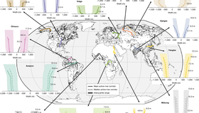
Wide-swath altimetry maps bank shapes and storage changes in global rivers
Here we present near-global-scale observations of active river channel geometry and associated monthly changes in water storage at the reach scale derived from the first water year (October 2023 to September 2024) of the Surface Water and Ocean Topography (SWOT) mission at 126,674 reaches worldwide.

US-French Satellite Takes Stock of World’s River Water
In a first, a space mission led by NASA and France has tracked Earth’s rivers swelling and shrinking from month to month over the course of a year and found significantly less of a swing than previous model-based estimates.
NASA’s Western Water Action Office (WWAO) Partners with Hazen and Sawyer to Improve Western Water Decision-Making Using NASA Earth Data
An exciting collaboration harnessing 65 years of NASA Earth monitoring and state-of-the-art data to support smarter water management across the Western U.S.