
PACE Terrestrial-Land Community Assessment
NASA’s Plankton, Aerosol, Cloud, ocean Ecosystem (PACE) mission is inviting the terrestrial-land community to provide insight into how PACE data products can be used.
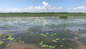
Delta-X Field Campaign Begins in Louisiana
Teams are heading out by land, water and air to collect data that will be used to forecast land gain and loss in the Mississippi River Delta as a result of sea level rise.
Humans Shifting Earth's Surface Water Storage
Using NASA's Ice, Cloud and land Elevation Satellite 2 (ICESat-2), scientists have shown humans are having a much bigger impact on surface storage variability than previously thought, with over half of the planet's variability happening in managed reservoirs.
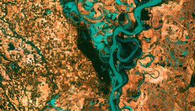
One Third of U.S. Rivers Have Changed Color
Rivers are among the most degraded ecosystems on Earth. The first map of river color from Landsat surface-reflectance data shows one third of U.S. rivers have changed color significantly over the last 35 years.
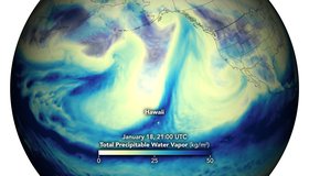
Potent Atmospheric Rivers Douse Pacific Northwest
In mid-January, the U.S. Pacific Northwest was soaked by several episodes of heavy rainfall, leading to widespread flooding and landslides. NASA data show these rivers in the sky.

Seeing COVID From Space
NASA is tracking the effects of the COVID-19 pandemic on our air, land, water and climate. The data have been collected in a free, openly-available online dashboard.

From Space to Farm
Farmers rely on the Landsat satellite to make decisions about crops, with far-reaching implications that can impact what we see on our dinner plate. In this curious video, Landsat's view of crops from space can be heard in the form of music.
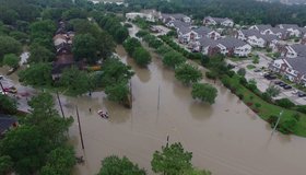
Satellites Improving Flood And Landslide Monitoring
NASA scientists Dalia Kirschbaum and Maggi Glascoe are using satellite data to pioneer improved landslide and flood alerting around the world.