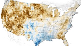
Western Soils And Plants Are Parched
For the second year in a row, drought has overtaken much of the U.S. from the Rocky Mountains to the Pacific Coast. Our Crop-CASMA soil moisture data portal, jointly developed with the U.S. Department of Agriculture, reflects the dry times.

PACE Terrestrial-Land Community Assessment
NASA’s Plankton, Aerosol, Cloud, ocean Ecosystem (PACE) mission is inviting the terrestrial-land community to provide insight into how PACE data products can be used.

Satellites Shaping Algal Bloom Monitoring Standards
Earth data are becoming more widely valued. For the first time, satellite data have been included in the World Health Organization’s guide on monitoring harmful algal blooms worldwide. The update draws directly from the Cyanobacteria Assessment Network, a multi-agency water project involving NASA.
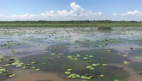
Delta-X Field Campaign Begins in Louisiana
Teams are heading out by land, water and air to collect data that will be used to forecast land gain and loss in the Mississippi River Delta as a result of sea level rise.

WWAO Passes Baton to U.S. Dept. of Agriculture
We have liftoff! NASA WWAO's new Soil Moisture Data System is operational and has been handed off to its partner, the U.S. Department of Agriculture, as the project comes to a close.

WWAO 2020 Annual Report
In the face of a global pandemic, 2020 underscored the need for data to drive decision making. Improving the way we manage water is as critical as ever. WWAO’s Annual Report, now available, summarizes how we endeavored to move the needle in 2020.
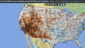
NASA Data Power New Soil Moisture Portal
WWAO's new soil moisture data portal - Crop-CASMA - is live. Crop-CASMA, which provides high-resolution, field-scale soil wetness from NASA satellites in an easy-to-use format, is a collaboration between NASA, the U.S. Department of Agriculture and George Mason University.

WWAO Request For Information
WWAO is launching new water projects in the U.S. Columbia River Basin. As part of this effort, we’re looking for information on activities using NASA data or technology that could address key water issues in the region.
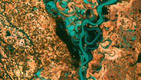
One Third of U.S. Rivers Have Changed Color
Rivers are among the most degraded ecosystems on Earth. The first map of river color from Landsat surface-reflectance data shows one third of U.S. rivers have changed color significantly over the last 35 years.
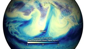
Potent Atmospheric Rivers Douse Pacific Northwest
In mid-January, the U.S. Pacific Northwest was soaked by several episodes of heavy rainfall, leading to widespread flooding and landslides. NASA data show these rivers in the sky.