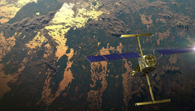
Latest Water Satellite Packs Engineering Punch
Meet the scientific heart of the Surface Water and Ocean Topography mission, which will see Earth’s water in higher definition than ever before.
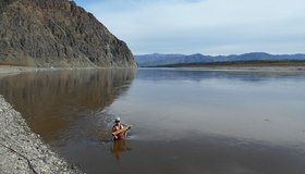
Water Mission to Gauge Alaskan Rivers on Front Lines of Climate Change
The upcoming Surface Water and Ocean Topography mission will provide a trove of data on Earth’s water resources, even in remote locations. Alaska serves as a case study.

Reaching New Levels in Groundwater Monitoring
As regions around the world face record-breaking droughts, scientists are using seismology to track groundwater levels, showing that well-managed pumping strategies have a big impact.
Boost in Drought Mitigation Funding from Inflation Reduction Act
The U.S. Department of the Interior has announced new funding to protect the sustainability of the Colorado River System. $4 billion will be focused on water management and conservation efforts in the Colorado River Basin and other areas experiencing similar levels of drought.

Helping Decision-Makers Improve Water Management
A new study from NASA WWAO and other agency partners sets out a roadmap for how environmental research and stewardship can come together.
The Great Shrinking Lake
In summer 2022, water levels in the Great Salt Lake dropped to new record lows. Increased water diversions and climate change are responsible.
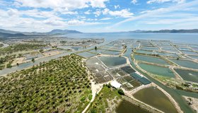
Shrimp Farm Shape Affects Groundwater Pollution
Coastal aquaculture has grown rapidly in recent decades. New findings may help decision makers optimize shrimp-farm layouts, which could help improve coastal water quality.
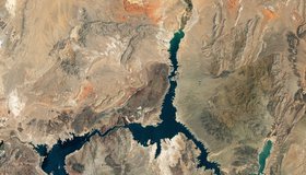
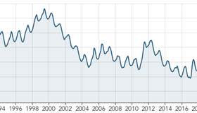
Nasa Images Show a Withering Lake Mead
Water in Lake Mead - the U.S.' largest reservoir - is at its lowest level since 1937 when the reservoir was filled for the first time. At just 27% capacity, NASA images offer a stark illustration of climate change and a long-term drought that may be the worst in the U.S. West in 12 centuries.
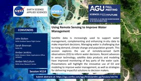
Call For Abstracts: Using Remote Sensing to Improve Water Management
WWAO is hosting a session at the 2022 American Geophysical Union Fall Meeting this December, jointly with NASA's Water Resources Program. Our session looks at how to improve water management using satellite Earth observations. We invite you to join us!

Event: 2022 National Water Use Data Workshop
The 2022 National Water Use Data Workshop will focus on improving water-data management and sharing. The event is led by WWAO collaborators including the Western States Water Council Water Information Management Systems Group, U.S. Geological Survey, Interstate Council on Water Policy, and Internet of Water.